The Okanagan Valley is the most densely populated region outside of British Columbia's lower mainland. This alone gives the area its own character. Beyond this, however, the physical landscape, historical events, significant pioneers, and government policies have combined over the years to make the Valley a unique region of the province.
Although manufacturing and tourism are important economic activities, it is the tree fruit industry that continues to define the Valley for residents and tourists alike. Perhaps the best way to begin exploring this orcharding landscape is to look at the physical characteristics that help define the region.
The Okanagan Valley is a long, north-south trench in the Interior Plateau of British Columbia. It extends north from the Columbia Plateau, in Washington State, to the height of land separating the drainage basins of the Columbia and Fraser Rivers. The main valley is occupied by Okanagan lake in the north and centre and by the Okanagan River and Osoyoos Lake in the south. Two smaller valleys lie parallel to the main trench. One begins south and west of Peachland and runs south to the Oliver/Osoyoos area. The other, more sharply defined, begins at Kelowna, runs north to Vernon, and is occupied by Wood and Kalamalka Lakes. At its southern end, the Okanagan Valley is only 5 - 10 kilometres wide. Toward the north the valley floor broadens to some 18 kilometres at Armstrong. From a few miles north of Armstrong (elev. 372M) the entire valley drains south to the Columbia River.
Between Vernon and the American boarder no major valley is tributary to the Okanagan; the watershed divides of the many small streams that do flow into the Okanagan are abnormally near the main valley. Most of the streams feeding the main valley are in narrow, steep valleys and have steep gradients.
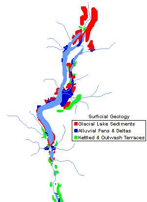
The Okanagan Valley can be divided into two broad physiographic areas: 1) the valley floor, consisting mainly of the Okanagan River floodplain, alluvial fans and deltas; and 2) the benchlands and kame and outwash terraces adjacent to the valley floor. It is these benchlands that became important to the growth of the region's tree fruit industry.
Okanagan bedrock geology presents a confused array of rock types, formations, and development sequences. These include basaltic lava flows, carbonaceous sedimentary beds, intrusive granites, and strongly foliated gneisses. Episodes of mountain building and erosion have modified the original geological structures.
Surface features of the Okanagan landscape are largely the result of erosion and deposition by stream action or glaciation. Large areas of Kelowna and Penticton, for example, are built on alluvial fans and deltas laid down since the last glaciation event some 10,000 - 15,000 years ago. Perhaps the region's most distinct surface deposits are the silt and clay cliffs that seem to form a ribbon along Highway 97 between Penticton and Summerland. These glacial lake sediments, or lacustrine deposits, sometimes how layers or "varves".
Important to the tree fruit industry are the many terraces that were built up as the last glacial period ended. These often consist of well-drained sands and gravels.
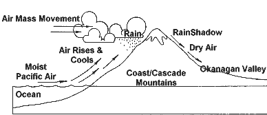
The Okanagan Valley is located in the rainshadow of the coast mountains and receives westerly air masses that have been modified in two ways to give distinct climatic features. First, as moist Pacific air masses are forced up and over the Coast and Cascade Mountains, they are cooled and their moisture falls as rain or snow on the windward side of the mountains. Second, as these air masses are forced down the leeward side of the mountains they are warmed and become more stable. In turn, the dried, warmer air promotes further evaporation from the surrounding landscape.
The winter climate in most of the Okanagan is dominated by a succession of Maritime Polar air masses, and the valley's highest precipitation is in December/January. Only occasionally do Continental Polar air masses "break out" over the Rocky Mountains to allow cold air to flow down the valleys and spread out over the Interior Plateau.
In the summer, temperatures rise and precipitation drops as the region comes under the influence of the Hawaiian High. Overall, the temperature range between summer and winter is double that found on the coast of the province, and precipitation is the lowest in souther Canada.
Within the valley, precipitation increases to the north as the valley bends towards the Monasheee Mountains. Precipitation also increases with elevation.
Mean daily temperature in the valley decreases from south to north and upslope, and this pattern is reflected in the precipitation records. The frost-free period varies widely throughout the Okanagan Valley and can fluctuate dramatically from year to year. On the average, harvest-damaging autumn frosts occur on the valley floor once every five years. They can be even more common on the benchlands.

Cultivable land in the Okanagan Valley is found on bottomlands, benches, and terraces, and they grade from south to north and upslope into four major soil types. These have developed in response to more humid conditions in the north and at higher elevations. As almost everywhere in British Columbia, the general pattern is interrupted often by peculiarities of slope, vegetation, parent material, exposure and aridity. Generally, well-drained soils that occur on the valley bottoms and benchlands are the best suited for orcharding.
At lower elevations, the Okanagan Valley is characterised by open parkland vegetation dominated by Ponderosa Pine, Douglas Fir, and Bluebunch wheat grass. At higher elevations the forest is more closed, and Western Larch, Western Red Cedar and Lodgepole Pine are found more frequently.
This open parkland was ideal for pioneering. It offerd enough trees to built houses, barns and fences, while the remainder of the land was "open" and eminently suited to grazing large herds of cattle.
Okanagan Indians are part of a large linguistic group os Interior Salish speakers. In the Okanagan Valley itself northern and southern dialects are recognised. In its entirity, their traditional territory may have stretched from Revelstoke south to the confluence of the Okanagan and Columbia Rivers at Brewster, Washington; and from the Nicola Valley east to the Arrow/Slocan Lakes region.
Archaeological efforts in the Okanagan has largely been in the form of survey work to ascertain the location, type and number of sites. Excavation work places the arrival of aboriginal peoples in the valley at roughly 8,000 years B. C.. These peoples probably moved in from the south as the last ice age retreated and as flora and fauna species gained a foothold.
From that time through to European contact, archaeological evidence suggests the region's people were dynamic in every sense. Their "tool kit" show a broadening range of items that exhibit increasingly sophisticated design. Their trade routes show evidence of connections with other groups hundreds of miles away. Evidence of hunting and gathering activities show a deepening knowledge of the territory and its resources.
![]()
![]()
© 1996-
INTERACTIVE BROADCASTING CORPORATION