The
Trails of Kokanee Glacier Park
Trails of the BC Kootenays
Overview:
The Kootenay region in British
Columbia is a quaint and unspoiled part of the province where three
different mountain ranges offer spectacular scenery. To the east are the
Purcells, while to the west lie the Selkirks and the Monashees. Between
these mountain ranges are deep valleys, beautiful fishing
lakes, lush green forest
and rolling grasslands. Wild
animals wander freely and outdoor facilities are everywhere. Many
provincial parks and
recreation areas have been set aside to preserve this region and these
sites are available so everyone can enjoy the Kootenay way of life.
Kootenay summers are warm with a moderate amount of rain, perfect for
outdoor recreation. Fishing,
hiking, mountain climbing, golfing, mountain biking, canoeing and kayaking
are all part of summer fun in this region. Winters are warm and moist,
with plenty of snow and great powder skiing. Heli-skiing, cross country
and ski-touring are also popular winter pastimes.
Information & Services
If you would like to have your business listed, please Click Here.
This area
is rich in history that dates from the 1890's when silver was king. Museums
and heritage building offer a glimpse of days gone by. The craft shops
and art galleries give us a good look at the present arts and culture
that thrives here. Get away from it all with a visit to British Columbia's
Kootenay Region.
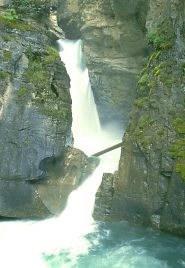
Hiking Kokanee Glacier Provincial Park and Recreation Area:
Established in 1922, Kokanee Glacier
Park is one of the most majestic in B.C. and is loaded with old mining
trails that the parks branch keep maintained. These old roads form the
nucleus for the 85 km (52.7 mi.) of hiking facilities throughout the park.
Trails are well marked and accessible, making for great backcountry hiking
adventures for the whole family. This rugged mountain wilderness is in
the Slocan Range of the Selkirk Mountains and named after the glacier
that sits on Kokanee Peak and the central focus of the park. More than
thirty turquoise-blue coloured lakes lie within the boundaries of the
park and recreation area, which makes for good fishing.
Facilities:
July, August and September are the best months for hiking in Kokanee Glacier,
but freak snowstorms do happen even during the summer months, so be prepared.
Camp in the designated areas
because the park does not have any developed campgrounds. Dogs are strictly
prohibited in Provincial Parks. Use a camp stove for cooking. Never set
up your camp near a trail or water. Limited accommodations are available
at Silver Spray, Woodbury and Slocan Chief. All three cabins are on a
first come, first served basis. A fee is charged when camping or using
the cabin facilities. Be prepared to camp outside if the cabins are full.
Because of the many porcupines, who like to chew on rubber, surround your
vehicle with chicken wire for overnight protection.
Access:
Two main roads, Highway 3A and Highway 31A, and five different access
roads act as different trailheads that lead into the central area of Kokanee
Glacier Park. Some of these roads are not for low clearance vehicles.
1. From Nelson, take Highway 3A for 19 km (11.7 mi.) to Kokanee Creek
and make your way for 16 km (9.9 mi.) to Gibson Lake.
2. From Ainsworth, on Highway 31, head north to Woodbury Creek and follow
this road for 13 km ( 8 mi.) to the trailhead.
3. From Kaslo, go northwest on Highway 31A for 6 km (3.7 mi.) to Keen
Creek and follow it for 24 km (14.8 mi.) to the Joker Millsite.
4. From Slocan City, on Highway 6, head north for 14 km (9 mi.) to Enterprise
Creek, follow it to the trailhead that is 13 km (8 mi.) further.
5. From Slocan, head south of 8 km (5 mi.) to Lemon Creek, follow it for
16 km (9.9 mi.) to the trailhead.
Trails:
Gibson Lake to Slocan Chief Cabin (access number one):
This trail starts at Gibson Lake, going over Kokanee Pass by Kokanee and
Kaslo Lakes and approximately four hours away is the cabin. This is a
moderate 10 km (6.2 mi.) hike that most can handle. From Gibson Lake,
enjoy direct access to Kokanee Glacier by way of the Keyhole trail, which
is between Gibson Lake and Kokanee Lake. This is a four to five-hour hike
over difficult terrain.
Woodbury Creek to Woodbury Cabin (access number two):
The trailhead starts at the park boundary, follows Woodbury Creek to Woodbury
Basin and the cabin. This 9 km (5.5 mi.) hike is rated as moderate and
will take about four to five hours. From Woodbury Creek to Silver Spray
Creek and cabin is an 8 km (5 mi.) difficult hike of approximately five
to six hours. It starts at the park boundary, across Woodbury Creek and
climbs to Clove Basin and Silver Spray Cabin. The Woodbury Creek - Sunset
Lakes route starts at the park boundary, up Scranton Mine Road to trail
and Sunset Lakes. This moderate 3 km (1.8 mi.) hike should take about
an hour.
Joker Millsite to Slocan Chief Cabin (access number three):
Starting at Joker Millsite the cabin is a moderate 5 km (3 mi.) hike.
Hiking time is approximately three to four hours. During periods in August
and September, this trail could be closed because of bears feeding in
the area. The trail that leads from Joker Millsite to Joker Lakes is a
5 km (3 mi.) hike that will take about two to three hours. They rate this
route as moderate.
Enterprise Creek to Slocan Chief Cabin (access number four):
Starting at the park boundary, this trail goes to Tanal Lake over Enterprise
Pass to Kaslo Lake and finally Slocan Chief Cabin. From the boundary to
the cabin it is about 10 km (6.2 mi.) and will take about five to six
hours of hiking this moderate trail. To reach Blue Grouse Basin over Paupo
Creek, the trail starts at Enterprise Creek and is a moderate four to
five-hour hike that is 6 km ( 3.7 mi.) in length.
Lemon Creek to Slocan Chief Cabin (access number five):
This unmaintained trail from the park boundary follows Lemon Creek to
Sapphire Lakes, then to Lemon Pass, by Kaslo Lake and finally to Slocan
Chief Cabin. The first leg of this hike is 10 km (6.2 mi.) that leads
from the trailhead to Sapphire Lakes. They rate this section as difficult
and will take from five to six hours to hike. At the east end of the lake,
there is a food cache and toilet. From Sapphire Lakes to Slocan Chief
cabin it is a moderate 4.5 km (2.7 mi.) trek. Suggested hiking time is
from two to three hours.
No matter which of these trails you hike, remember Kokanee Glacier Provincial
Park and Recreation Area is considered wilderness and is backcountry hiking.
This means staying on the trails, camping in designated areas, packing
out all your garbage and never taking any items from the park. Always
practice backcountry ethics and never, ever feed the wild animals. When
hiking in bear country, always
make noise, do not bury refuse as this will attract wild animals. Store
food by hanging it from a tree, use food storage containers, and never
keep food in the tent. Always be on the look out for bear signs. Hike
in a group. This will reduce the risk of animals attacking and hikers
getting lost. Children should not be allowed to wander and remember, leave
your dog at home. When hiking in the wilds of British Columbia always
be careful. Be safe, have fun!
For
more information contact: B.C. Parks
Site 8, Comp.5, R.R.#3
Nelson, B.C. V1L 5P6
Telephone: (250) 825-3500
Fax: (250) 825-9509

 Overview:
 Trails: